
Semiotic, so to appreciate the beauty of Guilin, it is necessary to go slowly and enjoy the walk. In Lijiang, feel the most beautiful landscape scenery, and then went Qianjiadong to find lost their homes ...
The first ten foot line: thousands of PANGXIDONG through - looking for lost homes
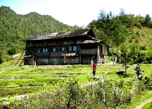
Qianjiadong between Hunan and Guangxi in the pathway are huge boulders. Qianjiadong also known as Mao Ping-dong, Chengfu hole peak leek Ridge, elevation of 2009.3 meters. Qianjiadong divided into upper and lower three holes, surrounded by high and low in the middle, overgrown, lush, in the blue sky against the background, like a beautiful prairie. Clustered into low-cavity water pool, water clear, is filling with river river tributaries show, the source of the river foam. It was said that there are one thousand people living Qianjiadong, one that because of the plague away, the second is due to be received official tax field to kill them off. This field, canals, gardens, fish ponds, Wuji, cemetery remnants, surrounded by ancient trees, animal tracks hoofed numerous birds, Cabot's Tragopan, monkeys, Tiger, pangolin, tiger frog, tits, golden pheasant and other rare animals in the forest Come and go from time to time. Rich cultural landscape and natural beauty, is Yao compatriots abroad to visit ancestral roots of the Holy Land, is a modern return to nature tourism destination. Through a variety of moves, the usual route is from the field into the Guanyang are Pangling Lin, Hunan Road, Tai Yuen Estate out of the county, totaling more than three days time, passing through uninhabited virgin forest, through the person of strength, perseverance And wisdom are a great challenge.
The first ten foot line: thousands of PANGXIDONG through - looking for lost homes
Qianjiadong between Hunan and Guangxi in the pathway are huge boulders. Qianjiadong also known as Mao Ping-dong, Chengfu hole peak leek Ridge, elevation of 2009.3 meters. Qianjiadong divided into upper and lower three holes, surrounded by high and low in the middle, overgrown, lush, in the blue sky against the background, like a beautiful prairie. Clustered into low-cavity water pool, water clear, is filling with river river tributaries show, the source of the river foam. It was said that there are one thousand people living Qianjiadong, one that because of the plague away, the second is due to be received official tax field to kill them off. This field, canals, gardens, fish ponds, Wuji, cemetery remnants, surrounded by ancient trees, animal tracks hoofed numerous birds, Cabot's Tragopan, monkeys, Tiger, pangolin, tiger frog, tits, golden pheasant and other rare animals in the forest Come and go from time to time. Rich cultural landscape and natural beauty, is Yao compatriots abroad to visit ancestral roots of the Holy Land, is a modern return to nature tourism destination. Through a variety of moves, the usual route is from the field into the Guanyang are Pangling Lin, Hunan Road, Tai Yuen Estate out of the county, totaling more than three days time, passing through uninhabited virgin forest, through the person of strength, perseverance And wisdom are a great challenge.
The second ten foot line: Pengzuping through - exploring Buddhist hermitages flash
Longsheng County Pengzuping Nature Reserve is located north of madi rural territory and resources County, Hunan Province, County and City step Xing'an County border, 45 km from the county, with a total area of about 50,000 acres. Big White Mountain highest mountain altitude of about 1,700 meters, complex landform forest areas, hills, ravines aspect, there is abundant natural vegetation, rugged and beautiful as the one set by the local people call "Little Huangshan, ""Little Mountains . "In protected areas Pengzuping have PANG series of landscape; with hemlock, pine and other rare animals and plants; a series of waterfalls of various shapes, including mountains up to 100 meters of silk waterfall; also worthy rival of Sichuan Emei Buddha PANG Guang, a scene known as the Longsheng, very attractive. General from across Pengzuping Longsheng madi Township, west, river springs out of the end of town, trips take two to three days.
Longsheng County Pengzuping Nature Reserve is located north of madi rural territory and resources County, Hunan Province, County and City step Xing'an County border, 45 km from the county, with a total area of about 50,000 acres. Big White Mountain highest mountain altitude of about 1,700 meters, complex landform forest areas, hills, ravines aspect, there is abundant natural vegetation, rugged and beautiful as the one set by the local people call "Little Huangshan, ""Little Mountains . "In protected areas Pengzuping have PANG series of landscape; with hemlock, pine and other rare animals and plants; a series of waterfalls of various shapes, including mountains up to 100 meters of silk waterfall; also worthy rival of Sichuan Emei Buddha PANG Guang, a scene known as the Longsheng, very attractive. General from across Pengzuping Longsheng madi Township, west, river springs out of the end of town, trips take two to three days.

The third ten foot line: Motian through - into the sea of green
Motianling in Xing'an County, the straight line distance from the county about 14 km, elevation 1078 meters. Motianling towering peaks around the valley and ax sliced form the breathtaking natural landscape here. Canyon plenty of water, lush vegetation, mountains, beautiful scenery, suitable for the season to this, the size of the waterfalls and pools of different colors, all over the valley. At an altitude of 800 meters or more, the distribution of rare in Guangxi alpine meadow. As a result of undeveloped area, so there remains a pure and beautiful natural landscape. Motianling walk through can be both for upstream, the line has some variety and difficulty, for those who like the natural landscape and the challenges his donkey, is a good choice. One walk through the line from a long-Qiu Ping Jin, melting along the valley until you come to Town, the entire process takes about 12 hours.
Motianling in Xing'an County, the straight line distance from the county about 14 km, elevation 1078 meters. Motianling towering peaks around the valley and ax sliced form the breathtaking natural landscape here. Canyon plenty of water, lush vegetation, mountains, beautiful scenery, suitable for the season to this, the size of the waterfalls and pools of different colors, all over the valley. At an altitude of 800 meters or more, the distribution of rare in Guangxi alpine meadow. As a result of undeveloped area, so there remains a pure and beautiful natural landscape. Motianling walk through can be both for upstream, the line has some variety and difficulty, for those who like the natural landscape and the challenges his donkey, is a good choice. One walk through the line from a long-Qiu Ping Jin, melting along the valley until you come to Town, the entire process takes about 12 hours.

Ten foot fourth line: Huaping through - the hometown of the vagus southern Falls
Huaping National Nature Reserve is located in Longsheng County at the junction with Lingui, there are flowers in bloom seasons, they have been known as the Fa Peng. Protected areas to Tin Ping Shan, Wei-Qing Ling, the main peak centered on the source of the formation of radial Liujiang River, where mountains, waterfalls, forests of protection, known as the southwest border of the plant and animal kingdoms. The current development of a Orang river, coarse river, Red Beach, Kwong Fuk four forest tourism area, with its rare and unusual "living fossil" silver fir, vast green forests, spectacular Xiquan beautiful waterfalls, magnificent steep ridges and peaks Valleys, colorful flowers and herbs and the spectacular natural landscape, so that visitors desire. Across the line from protected Lingui Huang Sha Ping River station, the red beach protection stations from Longsheng Huaping out, takes about two days. Can also reverse cross. The best season is through Huaping flowers bloom in April and May and the dry weather in October and November.
Huaping National Nature Reserve is located in Longsheng County at the junction with Lingui, there are flowers in bloom seasons, they have been known as the Fa Peng. Protected areas to Tin Ping Shan, Wei-Qing Ling, the main peak centered on the source of the formation of radial Liujiang River, where mountains, waterfalls, forests of protection, known as the southwest border of the plant and animal kingdoms. The current development of a Orang river, coarse river, Red Beach, Kwong Fuk four forest tourism area, with its rare and unusual "living fossil" silver fir, vast green forests, spectacular Xiquan beautiful waterfalls, magnificent steep ridges and peaks Valleys, colorful flowers and herbs and the spectacular natural landscape, so that visitors desire. Across the line from protected Lingui Huang Sha Ping River station, the red beach protection stations from Longsheng Huaping out, takes about two days. Can also reverse cross. The best season is through Huaping flowers bloom in April and May and the dry weather in October and November.

Fifth ten foot line: foot Baoding Mountain - Pilgrim's Journey
Baoding Mountain, also known as the South ding, located in Quanzhou County before the county at the junction of bay and Resources, Tourism Northern famous since ancient times, there is yin ship and Stone, Baekundong eight days and so spectacular landscape. Baoding Mountain, or Buddhist resort, halfway up the mountain have built in the Tang Dynasty Kulian Um, the whole truth as Amitayus Buddhist monks practicing the land; useful for hundreds of top section drilled granite, stacked building walls, open stone doors of the house From the temple. The mountains and temples are still strong incense, often encounter on the trails of pilgrims and monks and nuns pilgrimage. Gordon from Baoding Wufu reservoir junction mountain peak up to 6 hours or so. Peak is very broad vision, when fine weather ahead in the southeast city of Quanzhou County vivid scenery; facing west toward the resources, Longsheng, vast Hai, peaks Yong Tsui, mountains running. Down the mountain via the Liangcun, gold bamboo floor from the resource side of the return.
Baoding Mountain, also known as the South ding, located in Quanzhou County before the county at the junction of bay and Resources, Tourism Northern famous since ancient times, there is yin ship and Stone, Baekundong eight days and so spectacular landscape. Baoding Mountain, or Buddhist resort, halfway up the mountain have built in the Tang Dynasty Kulian Um, the whole truth as Amitayus Buddhist monks practicing the land; useful for hundreds of top section drilled granite, stacked building walls, open stone doors of the house From the temple. The mountains and temples are still strong incense, often encounter on the trails of pilgrims and monks and nuns pilgrimage. Gordon from Baoding Wufu reservoir junction mountain peak up to 6 hours or so. Peak is very broad vision, when fine weather ahead in the southeast city of Quanzhou County vivid scenery; facing west toward the resources, Longsheng, vast Hai, peaks Yong Tsui, mountains running. Down the mountain via the Liangcun, gold bamboo floor from the resource side of the return.

Sixth top ten foot line: foot really ding - the more the wonders of the city boulders
Real ding, ding that the North, the main peak for the more the city Ridge, located in the state, counties at the junction Resources, 2123.4 meters above sea level, second only to the cat mountain, second highest peak in South China. The southern end of its endless mountains, there are lakes, Block 13, with an average elevation of 1,600 meters, it is located in the mountains, known as Heaven Lake. Rare trees in the mountains, mostly low vegetation humilis, steep, slope were 70 degrees or more. Looking to the day from the real treasure on top of the lake, we can see the rolling hills dotted with several reservoirs, the scenery is spectacular exception. Fine weather, on top you can see in the real treasure MAOERSHAN and Hung Yen, the county seat of resources, it creates a false sense of compressed time and space. Ding dong really can walk the South began, the real ding the summit reservoir. Down to backtrack, or from the resources Meixi out, travel about two days.
Real ding, ding that the North, the main peak for the more the city Ridge, located in the state, counties at the junction Resources, 2123.4 meters above sea level, second only to the cat mountain, second highest peak in South China. The southern end of its endless mountains, there are lakes, Block 13, with an average elevation of 1,600 meters, it is located in the mountains, known as Heaven Lake. Rare trees in the mountains, mostly low vegetation humilis, steep, slope were 70 degrees or more. Looking to the day from the real treasure on top of the lake, we can see the rolling hills dotted with several reservoirs, the scenery is spectacular exception. Fine weather, on top you can see in the real treasure MAOERSHAN and Hung Yen, the county seat of resources, it creates a false sense of compressed time and space. Ding dong really can walk the South began, the real ding the summit reservoir. Down to backtrack, or from the resources Meixi out, travel about two days.

Ten foot line seventh: Maoershan foot - walking on top of the South China
One of the Five Ridges more MAOERSHAN City Ridge peak, across Hung Yen, resources, Longsheng three counties, 2141.5 meters above sea level, because if a cat is named Yamagata. Guangxi MAOERSHAN not only the first peak is the highest peak in southern China, known as "the Five Ridges very top, the summit of South China"reputation. The majestic mountains, ravines horizon, deep valleys, swift streams, is the Lijiang River, Zi River, the birthplace of Xunjiang, it sets the male Taishan, Huashan risk, Lushan Mountain of You, Emei of the show in one. Hai MAOERSHAN vast and very rich in flora and fauna, its climate quite the character, "mountain, Four Seasons, different day. " In 1934, the Red Army crossed the first mountain community in which old mountain. Flying Tigers during World War II World War bombing of the U.S. military aid to China in this mysterious disappearance. Spectacular views and beautiful legends, is attracting many people to explore. MAOERSHAN foot, usually selected from the gate and then climb to the ridge line of the ladder to the top of winding road, a distance of 20 kilometers, have to travel 8 hours or so. Peak is a mature tourist attractions, meals, lodging and other service facilities. A choice of walking down the mountain, 30 kilometers of winding roads, can travel back.
One of the Five Ridges more MAOERSHAN City Ridge peak, across Hung Yen, resources, Longsheng three counties, 2141.5 meters above sea level, because if a cat is named Yamagata. Guangxi MAOERSHAN not only the first peak is the highest peak in southern China, known as "the Five Ridges very top, the summit of South China"reputation. The majestic mountains, ravines horizon, deep valleys, swift streams, is the Lijiang River, Zi River, the birthplace of Xunjiang, it sets the male Taishan, Huashan risk, Lushan Mountain of You, Emei of the show in one. Hai MAOERSHAN vast and very rich in flora and fauna, its climate quite the character, "mountain, Four Seasons, different day. " In 1934, the Red Army crossed the first mountain community in which old mountain. Flying Tigers during World War II World War bombing of the U.S. military aid to China in this mysterious disappearance. Spectacular views and beautiful legends, is attracting many people to explore. MAOERSHAN foot, usually selected from the gate and then climb to the ridge line of the ladder to the top of winding road, a distance of 20 kilometers, have to travel 8 hours or so. Peak is a mature tourist attractions, meals, lodging and other service facilities. A choice of walking down the mountain, 30 kilometers of winding roads, can travel back.

Eighth top ten foot line: foot Tianshengqiao - the source of the magical journey Xiangjiang
Whitehead Tianshengqiao Xing'an County is located in 3 kilometers south of the township government, in the source cluster Depression in the Xiangjiang River, is a typical karst landscape. Whitehead Tianshengqiao is unique in the world Jiang Yuan Tianshengqiao group wonders, set within one kilometer of the four Tianshengqiao in one magnificent, has "hung, strange, dangerous, show, quiet, Austria, open"feature. In terms of its intensity, it is more than the "Asian of the most " natural Bridge Wulong title. Gui Tianshengqiao Gap on nearby reservoir, the source of the Xiangjiang River and well-preserved ancient villages in the Ming Dynasty - Qin Courtyard water source and other attractions, here is the hometown of Ginkgo biloba, beautiful fall scenery. Walking is a leisure Tianshengqiao line, very suitable for beginners to practice hiking and camping skills. Select from the high into the general, from the Whitehead out, the trip takes two days.
Whitehead Tianshengqiao Xing'an County is located in 3 kilometers south of the township government, in the source cluster Depression in the Xiangjiang River, is a typical karst landscape. Whitehead Tianshengqiao is unique in the world Jiang Yuan Tianshengqiao group wonders, set within one kilometer of the four Tianshengqiao in one magnificent, has "hung, strange, dangerous, show, quiet, Austria, open"feature. In terms of its intensity, it is more than the "Asian of the most " natural Bridge Wulong title. Gui Tianshengqiao Gap on nearby reservoir, the source of the Xiangjiang River and well-preserved ancient villages in the Ming Dynasty - Qin Courtyard water source and other attractions, here is the hometown of Ginkgo biloba, beautiful fall scenery. Walking is a leisure Tianshengqiao line, very suitable for beginners to practice hiking and camping skills. Select from the high into the general, from the Whitehead out, the trip takes two days.

Ninth ten foot line: Hunan, Guangxi, Old Commercial Road on foot - to listen to footsteps of history
This is a history of dust was frozen up, "Southern Silk Road. " Thousands of years, in northern Guangxi Lingchuan - Hung Yen - Jeonju - Shonan, there was an ancient land trade routes - Hunan, Guangxi, Commercial Road. It Zeng Yin Xiang, Li River upstream of the two rivers to poor water transport flourished 500 years and 30 years because of the last century, Hunan, Guangxi, the opening of rail and Guihuang Gong Road, the decline that has gradually been forgotten. Larix from Guilin Yao Hill to high, because the remote location, is still basically intact the ancient "Hunan, Guangxi channel " part of the modern civilization has not been disseminated. Among them, from the village of Lingchuan County Bai Ling Wang Ting Tin to Cheung Kong Village about 3 km section of Wuliting the best preserved, with Gusong Lin and Cheung Kong ancient buildings of Ming and Qing Ling. Villagers along the ancient trade routes, most of antiquity still exist, still adhere to the share of tranquil, living away from the hubbub of life. If you like the naturalness of the landscape and close to unpolished folk, this is a good line, one day and two days, and other moves.
This is a history of dust was frozen up, "Southern Silk Road. " Thousands of years, in northern Guangxi Lingchuan - Hung Yen - Jeonju - Shonan, there was an ancient land trade routes - Hunan, Guangxi, Commercial Road. It Zeng Yin Xiang, Li River upstream of the two rivers to poor water transport flourished 500 years and 30 years because of the last century, Hunan, Guangxi, the opening of rail and Guihuang Gong Road, the decline that has gradually been forgotten. Larix from Guilin Yao Hill to high, because the remote location, is still basically intact the ancient "Hunan, Guangxi channel " part of the modern civilization has not been disseminated. Among them, from the village of Lingchuan County Bai Ling Wang Ting Tin to Cheung Kong Village about 3 km section of Wuliting the best preserved, with Gusong Lin and Cheung Kong ancient buildings of Ming and Qing Ling. Villagers along the ancient trade routes, most of antiquity still exist, still adhere to the share of tranquil, living away from the hubbub of life. If you like the naturalness of the landscape and close to unpolished folk, this is a good line, one day and two days, and other moves.

Tenth ten foot line: foot Lijiang - experience the most beautiful landscape views
"Semiotic, Li River scenery in Xingping, " Yang Di to Xing Ping area is the most beautiful section of the Lijiang River scenery. Lijiang is a more mature foot line, a distance of about 15 km, about 5 to 6 hours to go, basically along the riverside path and the ridge walk. All the way to fame, the way many famous attractions, you walk up close and Lijiang River. Way to go well, basically there is no need to uphill and downhill of the place, and can always find the locals ask, do not worry about getting lost, the whole process is very relaxed and safe walking, is new to the outdoors the best new entry route .
"Semiotic, Li River scenery in Xingping, " Yang Di to Xing Ping area is the most beautiful section of the Lijiang River scenery. Lijiang is a more mature foot line, a distance of about 15 km, about 5 to 6 hours to go, basically along the riverside path and the ridge walk. All the way to fame, the way many famous attractions, you walk up close and Lijiang River. Way to go well, basically there is no need to uphill and downhill of the place, and can always find the locals ask, do not worry about getting lost, the whole process is very relaxed and safe walking, is new to the outdoors the best new entry route .
没有评论:
发表评论